Buckeye favors grid model for 2,000-acre Landing mixed-use center with 8,000-11,000 units
City council received workshop presentation on The Landing Specific Area Plan for 2,000-acre mixed-use activity center with three draft scenarios (8,000-11,000 units) and provided feedback on density, building heights, infrastructure readiness, and transit options before plan refinement in early 2025.
Buckeye Council Signals Preference for Grid Model at Landing Specific Area Plan Workshop; Infrastructure Bottleneck Remains Unresolved
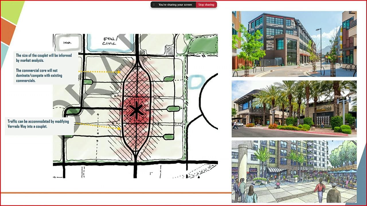
On December 17, the Buckeye City Council convened for a workshop on The Landing Specific Area Plan, a 2,000-acre mixed-use activity center designated in the 2019 General Plan as the Gateway Activity Center. The presentation by Matrix Group consultant Ed Boy outlined three competing land-use concepts, each capable of absorbing the market-study estimate of 8,000–11,000 residential units. While council members expressed directional preference for a pre-planned grid model and demanded safeguards on building height and density, the meeting exposed a critical unresolved dependency: the interstate and arterial infrastructure improvements—particularly I-10 interchange at Dean Road and Verrado Way widening—that are essential to the project's viability remain subject to state and federal funding decisions that have shifted adversely.
Lead Paragraph
The Landing represents the city's most significant planned activity center outside downtown Buckeye. The General Plan designates it as a place for "intense commercial uses" and higher-density residential to support retail, entertainment, and employment. Market analysis indicates the area can absorb 8,000–11,000 dwelling units, which at 3.2–3.3 persons per household translates to a potential population of roughly 17,000 across 2,000 acres (approximately 3–4 dwelling units per gross acre—comparable to surrounding Buckeye subdivisions). However, council members—particularly those responsible for transportation and fiscal oversight—pressed on an uncomfortable reality: I-10 already backs up for a mile to access the freeway, Verrado Way is congested, and Arizona Department of Transportation (ADOT) has withdrawn state funding for I-10 widening. Without commitment to infrastructure improvements that predate or accompany dense development, the plan risks replicating the congestion that already plagues the west valley.
Key Speeches
"I do believe that your Traffic Engineers and City Engineers have considered that as part of our discussion with this already and they are aware that none of this really gets off the ground without those interchanges being put in place and upgraded." — Ed Boy, Matrix Group consultant
"State land's the majority land holder in this area and the thing they have repeated to us over and over is they're going for the highest and best use which often for them for the highest return is going to be that maximum their density where they can so we're not saying it will end up at 177,000 potentially can be 177,000." — Ed Boy, acknowledging state land's profit motive
"I would not like to see tall buildings in that area…our logos mountains if you put the buildings too close can't see mountains so I'm more maybe two story the most." — Jamaine Berry, on viewshed preservation
"This is our attempt to telling both state land and the developers this is what we want to see in this specific area…anybody can pick it up and just do a seat of the pants and it's going to look like every other neighborhood that's throughout the Metro area and we'll lose an incredible opportunity to drive the development that we want to see happen in this location." — Kenda, Planning Manager, on the strategic importance of an adopted framework
"I would be much more leaning towards a grid concept than the divided than that okay good feedback." — Mayor Eric Orsborn, indicating council consensus on the preferred scenario
Timeline
- Applicant presentation: Matrix Group (Ed Boy) presented three draft land-use scenarios totaling approximately 1 hour and 15 minutes.
- Community and stakeholder engagement to date: Community meeting at Summit Church (ca. 65–70 attendees, 180 comments); two recent workshop sessions (81 combined comments); Planning and Zoning Commission review; technical staff committee input; ongoing conversations with State Land, Azzo, West Mech, and Maricopa County Flood Control District.
- Council discussion: Approximately 45 minutes of council questions and feedback, with five council members offering input on density, infrastructure, heights, economic tools, and scenario preferences.
- Vote: No formal vote. Directional feedback only; council indicated preference for grid-based scenario and requested further refinement.
The Three Scenarios
Scenario One: Neo-Traditional with Verrado Way Couplet
This approach mimics traditional master-planned communities with a central pedestrian core. Verrado Way would split into a one-way couplet (northbound and southbound) enclosing a pedestrian-oriented commercial and entertainment district modeled conceptually on Pearl Street in Boulder, Colorado, or the Scottsdale Boulevard/Drinkwater split in Old Town Scottsdale. The consultant noted that the split provides a "really neat marketing opportunity" to drive visitors toward a pedestrian mecca while reducing through-traffic conflicts. Residential density would decrease concentrically from the core, buffering adjacent subdivisions (Blue Horizons, Sundance) from intensity.
Scenario Two: Pre-Planned Grid ("Phoenix 2.0")
The second scenario adopts a regular grid of north-south and east-west streets, all designed for pedestrian orientation but distributing traffic more evenly across the area. The consultant explicitly compared this model to Barcelona, Spain—a city frequently cited as a best-practice mixed-use environment. The grid offers State Land "a lot of predictability" and flexibility for parcel-by-parcel sale and development, allowing organic district formation as the market dictates. However, the consultant acknowledged this approach is "infrastructure heavy" and "would likely require probably more support from the city to make a reality…from a pre-planning pre-financing or whatever."
Scenario Three: Green Belt/Desert Drainage with Downtown Gilbert–Sized Core
The third scenario leverages natural grades, retention basins, and green infrastructure to create a regional storm-water management system while establishing parks, trails, and recreation amenities. The downtown core is scaled to match downtown Gilbert's size—a proven, vibrant mixed-use neighborhood with growing restaurant and entertainment scenes. Residential development would be predominantly suburban single- and two-family, with lower overall density but regional recreational draw from the Maricopa County Flood Control District basin.
Opposition & Concerns
While no formal opposition testimony was recorded, council members articulated several concerns that functionally operate as constraints on the plan:
-
Infrastructure capacity insufficient: Council Member Hagg (implied) and other members raised that I-10 already backs up one mile, Verrado Way is congested, and ADOT has withdrawn state funding for Interstate widening. "Who's going to rebuild the bridge on I-10?" and "We've got to rely on the state to do that with their money and they've already pulled the funding to widen Highway 10" were the core questions.
-
Dean Road improvements not guaranteed: Council members stated that Dean Road connectivity is "non-negotiable" but noted no formal ADOT commitment exists. The consultant admitted, "I don't have that answer today but I do believe that your Traffic Engineers and City Engineers have considered that as part of our discussion with this already."
-
Truck traffic through residential areas: Council members raised concern that heavy industrial trucks from the warehouse site south of the Landing would route through the Verrado Way couplet if it becomes the primary arterial. The consultant acknowledged the city cannot legally enforce truck routes—only "encourage" them through street design.
-
Density and population scale: One council member requested a cap on units "well below 8,000–11,000" and expressed discomfort with the 17,000-person projection. The consultant countered that 3–4 dwelling units per acre is not unusually dense and comparable to surrounding subdivisions.
-
Tall building viewshed impact: Jamaine Berry objected to tall structures, citing a visible warehouse building in the valley: "That big Warehouse to the south is just extremely Too Tall no matter where I'm at in the valley I can see it and not see the base of the valley." He advocated for a maximum two-story height limit.
-
City general-fund subsidy precedent: Council Member Hagg questioned whether "city participation" in infrastructure meant drawing on general fund or property taxes, and expressed concern about subsidizing development in one area but not others, setting an unfair precedent.
-
Uncertainty of state land's intentions: The consultant noted that State Land, the major landowner, repeatedly emphasized "highest and best use," which typically means maximum density for maximum return. This creates tension between the city's desire to shape the plan and State Land's profit motive—an inherent conflict the plan cannot resolve unilaterally.
Support
Council members and city staff expressed strong strategic support for the activity center concept as a way to diversify Buckeye's economic base and create a destination-quality mixed-use environment.
-
Mayor Eric Orsborn and Council Member Hagg articulated that the activity center is a rare opportunity to build at an urban scale—comparable to downtown Scottsdale, downtown Chandler, or Arizona State University's campus. Council Member Hagg stated: "This is exactly where we want to see that scale up and you can create some really special environments…with that scaled up whether it's residential or it's like a Kieran concept or a Scottsdale quarter this is our opportunity to do that."
-
Planning Manager Kenda emphasized that an adopted framework prevents future development from becoming generic suburban sprawl. Without the plan, she noted, "state land will put it up for auction…you'll have a developer that picks it up and they have all kinds of ideas about what they want to see there" and the city risks losing the opportunity.
-
Clay Goodman expressed preference for the grid scenario, citing its flexibility and ability to create "naturally formed or organic districts."
-
Council members supported exploring transit options (trolleys, street cars, e-bikes, e-scooters, park-and-ride connections) and micromobility as part of the long-term vision, even if not day-one infrastructure.
-
Ed Boy noted that market study findings confirm the west valley has significant household formation demand and Buckeye can absorb substantial housing, making the landing financially viable from a market perspective.
Project Details
- Case number: Not stated in transcript.
- Applicant/Proponent: City of Buckeye (through Planning Department) with input from State Land (major landowner), Azzo, West Mech, and Maricopa County Flood Control District.
- Consultant/Planner: Ed Boy, Matrix Group.
- Location: South of Interstate 10, east of Verrado Way, generally bounded by the old Luke Air Force Base auxiliary field and extending south toward the warehouse industrial area. Approximately 2,000 acres, 3.5 miles (north to south) and 0.5 miles (east to west), located in Buckeye.
- APN: Not stated in transcript.
- General Plan designation: Gateway Activity Center (2019 General Plan, approved by council and ratified by voters).
- Current zoning: Not explicitly stated; consultant indicated existing codes allow taller buildings in commercial areas and developers may have expectations accordingly.
- Proposed zoning/Framework: Specific Area Plan with refined regulatory tools focused on public realm (streets, public amenities, trails); policy guidance for private property zoning and design to be determined in subsequent regulatory updates.
- Units and density: Market study indicates 8,000–11,000 residential units can be absorbed; potential population 17,000 at 3.2–3.3 persons per household; gross density approximately 3–4 dwelling units per acre (comparable to surrounding Buckeye subdivisions).
- Changes from previous versions: This is the first formal council workshop; previous engagement included community meeting (65–70 attendees, 180 comments) and two public/workshop sessions (81 comments).
Vote Breakdown
No formal vote was taken. The workshop was consultative; council provided directional feedback to guide plan refinement.
- Preference indicated: Grid-based pre-planned scenario (favored by Clay Goodman and Eric Orsborn).
- Constraints noted: Height limitations, infrastructure coordination with ADOT, and unit-count review requested.
- Decision pending: Adoption anticipated after public draft document is released early 2025.
Outcome & Next Steps
The city will refine the landing Specific Area Plan through the end of 2024 by incorporating draft goals, policies, and narratives for three identified sub-areas: the campus area (north of Verrado), the recreation/green belt area (Maricopa County Flood Control District basin), and the mixed-use state land area (south of Verrado). These refinements will be filtered through city technical staff and planning department for recommendations.
In early 2025, the city will release a public draft document and conduct additional community engagement. The plan will then return to council for formal review, adoption, and implementation.
Tours planned: Staff will organize comparative site visits (modeled after previous downtown Scottsdale, downtown Chandler, and Tempe tours) to familiarize council members with similar mixed-use, walkable community examples. Possible destinations include downtown Scottsdale, Chandler, Tempe, and Barcelona (as suggested by the consultant).
Coordination still undefined: The critical dependency—ADOT and federal funding for I-10 Dean Road interchange improvements and Verrado Way widening—remains unresolved. The consultant stated that city engineers are "aware that none of this really gets off the ground without those interchanges being put in place and upgraded," but acknowledged that details of interaction with ADOT, the federal government, and funding mechanisms will be "confirmed as this plan moves through draft into final."
Controversies & Context
Infrastructure Constraint as Feasibility Bottleneck
The most significant tension at the workshop was the apparent mismatch between the market-based residential absorption capacity (8,000–11,000 units = 17,000 residents) and the existing regional transportation infrastructure. I-10 already backs up for one mile; Verrado Way is congested; ADOT has withdrawn state funding for I-10 widening. Council Member Hagg's repeated questions—"Who's going to rebuild the bridge on I-10?" and "Where are we going to get the state to cooperate to rebuild the interstate highway that we're going to need for this?"—remained unanswered. The consultant could only reiterate that city engineers are aware of the requirement and that ADOT coordination strategy would be "confirmed as this plan moves through draft into final." This is a material contingency: without new I-10 and Verrado Way capacity, dense development risks gridlock that would undermine the activity center's market viability and quality-of-life appeal.
State Land's Profit Motive vs. City's Placemaking Goals
State Land (the major landowner) has consistently communicated a preference for "highest and best use," which in real-estate terms typically means maximum density and maximum units for maximum return. The consultant acknowledged this tension: State Land wants "predictability…with the land planning but also…flexibility." This creates an inherent conflict: the city is crafting a plan to shape the character and scale of development, but State Land—by virtue of land ownership—retains substantial leverage to push toward higher density if market conditions support it. Council members flagged this implicitly when asking about density caps and whether the consultant's 8,000–11,000 unit forecast was a floor or ceiling. The plan framework may guide but not bind State Land's decision-making.
Building Height and Viewshed Preservation
Council Member Barry's objection to tall buildings—citing the visibility of a large warehouse structure across the valley and advocating for a two-story maximum—represents a values conflict between preserving scenic mountain views (a quality-of-life amenity) and enabling the density and building types necessary for a successful mixed-use activity center. The consultant acknowledged that current codes allow taller commercial buildings and that developers may expect to build taller, but agreed to explore height restrictions "while maintaining market viability." This is a soft commitment: without clear height caps in the Specific Area Plan's regulatory framework, future zoning amendments could allow taller buildings if market demand and developer pressure justify them.
Truck Traffic Routing and Legal Limits
Council members raised that truck traffic from the warehouse site south of the Landing would inevitably route through Verrado Way if it becomes the primary arterial, negating pedestrian and placemaking goals. The consultant and staff acknowledged that the city cannot legally enforce truck routes—only encourage compliance through street design (e.g., narrower arterials to discourage trucks). Jack Rabbit Trail was mentioned as a potential alternative, but absent state highway designation or enforcement mechanisms, truck routing remains subject to trucker discretion. This highlights the plan's limited regulatory reach on regional traffic behavior.
City Infrastructure Investment and Fiscal Precedent
Council Member Hagg questioned whether "city participation" in the plan meant direct general-fund or property-tax expenditure. The consultant clarified that participation could take multiple forms: Community Facilities District (CFD), improvement districts, developer investment with property-tax return, or "creative financing" akin to what was used at Vestar or employment-center districts. The distinction matters because Buckeye has a limited roster of activity centers (six total, per the Planning Manager); if the city commits general-fund money to landing infrastructure, it may face pressure to do the same elsewhere, straining municipal finances. The consultant's vague commitment to "more refinement" on this point suggests it remains unsettled.
Market Viability and Housing Type Mix
The consultant presented a nuanced but easily overlooked point: the 17,000-person figure is not destiny. If the city insists on suburban single-family development, household size will be higher (3.2–3.3 persons) and population will reach 17,000 at the same unit count. But if the plan emphasizes mixed-use and walkable apartments, the household mix shifts toward young professionals, dual-income couples, and smaller families, lowering the average household size and thus the total population—while increasing income and retail spending. This is a planning lever, but one contingent on the developer's market calculus, not the city's preference.
Public Engagement Summary
The plan has undergone three rounds of formal stakeholder engagement prior to this council workshop:
- Community meeting (early 2024): Approximately 65–70 attendees at Summit Church in the Landing area; 180 written and verbal comments.
- Two public/workshop sessions (recent): Over 60 in-person attendees at City Hall East; 81 total comments (verbal, written, or on comment cards).
- Planning and Zoning Commission review: Commissioners provided directional feedback on scenarios, goals, policies, and foreseeable pitfalls.
Common themes from public comment included strong support for Dean Road connectivity, buffering and separation from adjacent established subdivisions, clear gateways and wayfinding, and enhanced connectivity to Blue Horizons (to reduce reliance on arterials).
Duration
- This item (Landing Specific Area Plan presentation and discussion): Approximately 2 hours (including Ed Boy's presentation, staff context, council questions and feedback).
- Total meeting: Approximately 2 hours and 15 minutes (workshop item only; no other agenda items presented during the transcript period reviewed).
Other Notable Items
The transcript does not indicate other substantive agenda items beyond the Landing Specific Area Plan workshop. The meeting concluded with the Mayor proposing a tour of comparable developments (downtown Scottsdale, Chandler, Tempe, and possibly Barcelona) in the first couple of months of 2025, with staff to coordinate.
View source transcript ▼
Source: Buckeye City Council Meeting 12-3-2024 — December 3, 2024. Auto-generated YouTube transcript; may contain transcription errors.
e e e 2024 roll please counciler Barry presc Goodman Council mad is absent counc member beard May H here pres thank you very much uh Workshop items 2A is presentation and discussion regarding the landing specific area plan uh we'll Ki it off seanna senior planner mayor I appreciate mayor members of the council um welcome this is going to be the third of our workshops here uh we actually had one with the Planning and Zoning commission um just last month and as well as had a general with the public so uh we're here to to gather information about this exciting project called The Landing um part of our general plan as as the um Gateway Activity Center uh We've named it the landing uh with such logo representing the auxiliary field this evening uh but we're going to gather information and take that information and well I'm not going to take the information Matrix from Ed boy is going to take that information that he's Gathering from this meeting and take it to uh and suable format that we're going to take forward uh for hopefully for approval soon so uh with that without further Ado I'm going to hand the time over to Ed boy from Matrix cool thank you Sean and uh I apologize for my voice today I'm getting over bronchitis but you guys are important to me so that's why I show up Mr Mayor thank you but uh because of that I'll also kind of keep this a rather short presentation to the point um really quick for the the benefit of everyone I'll go through the project own overview really quick um and talk about some of the progress we've had so far the milestones and then go through some of the draft land use scenarios have been part of those workshops over the last month or two so really quick uh this is a specific area plan and we've talked about this once before this is a tool that allows for conversely and very intuitively it's not a general plan um whereas generals is more specific but it also gives you the ability to do some more enhanced land planning and even regulatory um tools to help you bridge the gap until more robust zoning standards are put in place for this area and as I noted before the most uh the extent of the regulatory tool that is anticipated at this point is primarily focused on the public rights away public realm streets public amenities and trails and things like that and provide rather more of the policy guidance for any zoning or design at this point be effective on private property just so that we can continue to have those um open conversations with the land owners as the uh plan gets implemented so really quick this is the area that is um along and south of it 10 at R away it contains the old Loop hor base auxiliary field as well as a good chunk of land that is under the perview of Maricopa County Flood Control District over 2,000 acres 3.5 miles so it's a big area and there's a lot of opportunities there so Sean noted we did have this is the third of the set of in interactions with different entities but we did have some Community meetings early on in the year we have really good attendance at a community meeting um up in the landing area at Summit Church and we uh had lots of attendees show up 47 for sure more than likely about 65 to 70 some people don't sign in lots of boards and activities 180 comments received and then more recently we had over 60 attendant inperson update that showed these land use scenarios here um at City Hall East um in the landing and we showed the three future Landing stals went through a a presentation got 81 comments whether they were verbally provided to us or written on a comet card or provided on the draft uh concept land use scenarios as well the technical committing of Committee of City staff has been intimately reviewing uh these scenarios as well as providing us additional Direction on how to make sure this is not just a pie in the sky plan but something that can work it's something that can be implemented so each of the committee members gave us some markups and Direction and uh gave us guidance on many of the policies that are being adopted and moved forward for integration and to be related properly to The Landing plan area Planning Commission did much like what you did There's a a little bit hand on a little bit more Hands-On yours it's going to probably be hopefully a bit more um directive with policy but they went through all of these different land use scenarios they gave us some ideas for plans and policies and goals and pitfalls that they foresaw for the area and we've got that put into our stock of comments as well as we're beginning to flesh out what this plan looks like from a draft of goals policies um actions perspective so one of the things that's driving our decision making and we to get the final but some of the early findings from the draft Market study that we provided to staff and discussed with staff are that there is a lot of household formation a lot of households that need to be developed in the West Valley of uh Phoenix Metro area in particular Buckeye has in the position to absorb a great great quantity of those houses which will drive a lot of the development that could occur in the landing in short what we are omic consultant is telling us right now is that whatever number of units that are 8 to 11,000 that is negotiated with Luke Air for Spas through the graduated density concept that amount of housing can easily be accommodated and picked up by The Landing itself which is really good news because the housing that is needed is going to support the economic opportunities that could come in this area as well one of the things that this uh the Economist is working on is trying to see what that Max threshold might be so that we can understand how many more houses how many more dwelling units might be able to be put into this landing area um and further enhance the market opportunities in the landing I mentioned that because again this is 3 and a half square miles over 2,000 acres as it is right now there's a lot more room for development in there especially the asp ations of having an intense mixed use area remained through this period and the economics and Market study says that can be realized and here's your horizons and from what we understand that's something we probably want to continue to promote through this plan and strategies for how to interact with Luke Air Force Base excuse me and other players as uh we move towards the conclusion of this project so importantly the uh housing is trying to capture an audience that we currently aren't completely capturing in Buckeye and that being a lot of younger professionals small families people are just getting started um that don't desire to have a formal detach single family home but somebody who wants a more Dynamic living environment that's perhaps even a mixed use building or a more densed apartment buildings in a more of a walkable environment and that's what the landing has always been predicated upon from the beginning is that as a taret target market that there Prime an opportunity to select here so other industries that will help align with that that could be part of the um economic solution include US Financial Services professional Technical Services research and development Education Health Services and some of the technical traits that are um being developed in programs with West Mech right now if you can get that Confluence of Education high technology um high paying office Class A type jobs you can really create an incredible node here that's going to capitalize upon the existing assets the virginy assets and those assets yet to come just a note West ma is misspelled I see that and I apologize I I know put the T there um draft land use scenarios so this is where we're looking for a little bit of feedback from you mostly I would consider this to be a good Workshop if I could find out what do you like um what elements would be good to pull from other ones uh also if there are things that are just non-starter stuff that we should not even think continue to think about because of the complications with it the impracticality or whatever it might be now I'm presenting to them to you because they are drafts they are Concepts they are not fully fleshed and they don't represent an A A A use allocation that's necessar grounded in reality that's the next iteration this is to get the concepts out there give you something to see and react to and then from that we will take the market study information the guidance from this meeting and all the other meetings and pull it together in a more refined uh final selective land use approach for this area so some of the general considerations is that in all of these cases campus style development is likely to be best supported north of vanard because of the exposure to i1 lots of visibility more Suburban nature so and lots of land that's not necessarily um uh suitable to be developed in in in a more of a master plan area other than to support those campus opportunities whether it's a medical campus research campus education campus or some sort of economic driver that's going to want to have exposure in I 10 there's a huge Recreation opportunity in coou Maricopa County flood control District as we talked about closer to jack rabbit with the flood control district Basin so that Still Remains as a very desirable outcome through all of our interactions and Outreach so far with all stakeholders the design character and theming of this entire development will be developed and carried through all the different sub areas that are part of this and I I classify we we see this area as having three areas the area north of Van that's already under well underdeveloped velopment the area by the Flood Control District uh Basin that is um more of a recreation center point and then the estate land chunks that are south of van and that um are the real meat of the opportunity that could be developed in the landing area so the design because we have these three different flavors inside the landing the design elements the theming the trails the signage way finding should carry throughout that area so that people know where they're at it's really that way you create that strong identity a marketing piece for that area as for economic development strategy because this is trying to make something occur that's probably going to need some City support that partnership's important The Economist is going to be developing some strategies or at least giving us examples as well of what has worked in similar circumstances elsewhere what tools might need to be promoted at a state level to help you know Prime the pot or prime the engine a little bit more uh so Arizona's got a a pretty limited scope of economic tools that are available as we all know so if there's more we can promote we'll make sure that those get in front of uh you as well for consideration it's very important to the public that arterial performance is advantaged so we are making commitment with any of these Landes plans and working with the city staff as well that the arterials will not become logged or delays they will get people to where they want to be and we will give them every reason in the world to want us get to the middle of this area and do their shopping living and working and playing in this area as well but nonetheless um knowing that I 10 needs another interchange at Dean Road knowing that the verado interchange is going to slowly becoming uh having a portal level of service it's important that we make sure that the output of those roads is maintained despite any land planning that might occur again working with Luke Air Force Bas and I mentioned future Dean Road so this first one is illustrating and again a very broad concepts of a neotraditional setup this is very similar to um some of the land planning that was done with verado and that you have neighborhoods that are up budding a more of a central core area where that dark red area is with the uh small asteris or the larger asteris asteris um that could be a good Civic event activity you know economic driver of an area you'll notice that verado way kind of splits there that would create a Northbound southbound oneway couplet around that area which I'll show another slide which would be a really neat marketing opportunity to drive people towards that visually but then inside that area create a very welcoming and safe uh one-of-a-kind pedestrian experience for this part of the state not unlike Pearl Street in uh Boulder Colorado as an example where it's a pedestrian oriented area lots of dining night life activity and so on very special they didn't Pearl Street grow up around an area that was already done so that's they dropped it in afterwards so that's part of the difference here we are going to be this is an opportunity to create it from scratch and let that occur with this plan en vision in mind whereas Pearl Street or other pedestrian are is um you're right they were built environments that supported that as a conclusion we can build a framework with this plan ahead of time to consider that so that's what we're trying to but there one potential solution does it have to be a pedestrian Way Lake Pearl Street no it might be even like a low tra a a slower Road smaller scale lower traffic speeds um that pedestrians can feel safer at we can have the outdoor dining outdoor activities nonetheless in that area this just provided as a visual example of what could be an outcome for that also it doesn't have to be as big as represented here in fact if you built it as big as represented here as an activity economic commercial core it's probably far too much um land for the market that's there so we know that has to be scaled back but for the purposes of introducing the concept we wanted to make sure it was big and shows what that maximum opportunity could potentially be so the density for res can I just to back up and for perspective on this the size of area we're talking about how does this relate to like a say a downtown TP or a uh Downtown Phoenix or uh asus's campus right Tempe this is this is probably more similar to downtown Tempe plus asu's campus and then probably down Apache quite a bit Yeah in that area because it's it's a large area and the scale can get is leading in this large area that's nearly 1 mile north to south and probably you know this is rough and it's not really two- scale but maybe a third of a mile east to west it's a large area and the reality is is that we have some other Concepts to illustrate more um well reged but more smaller sized downtowns that we could show and illustrate how those look in the concept of this entire area and why it's important we mentioned this is that there's a lot of land to plan here and it's important we understand scale from what the numbers where you were throwing out earlier you're looking at residential about 17,000 people correct if you're looking at the numbers of around 3 to 32 per unit 8 to 11,000 that's accurate have you been on verado in the morning yes and seen it ped up all the yes so who's going to rebuild the bridge on I 10 correct that's the some of the considerations that we're being careful of is that we don't over plan the area without thinking about how it interfaces with those other Transportation infrastructure requirements it's already backed up I mean you're talking about 177,000 people in an area that right now backs up a mile just to get on any interstate highway that only has one lane going right into the city you're looking at the retail even there yet you're looking at completing McDow over to Rainbow excuse me over to Jack where there only stop signs who's going to advance this and get this something going on the streets instead of building buildings we already have warehouses up there are there any plans on putting more warehouses and more hospitals before we start planning on 17,000 people in about a 4 square mile area Okay so councilman um to answer your questions whether or not you produce we do this plan for the Buckeye Landing that number of units is going to be built in this area it could be all single family homes it could be according to the plan that we're developing right now some developer will buy the land from state land and the other entities out there and 17 you know thousand people will end up there because it matches what Luke Air Force Base has outlined as part of their graduated density concept so in any case Air Force V on correct the zoning that's in place as well can allow for much of that as well as the land use planning that's already in place to the general plan as with any development the city always looks at traffic numbers traffic management before decisions made because it is not a good decision to make things worse without having the development Community pay their required share to keep that infrastructure safe and healthy and flowing so while go ahead correct me if I'm wrong isn't that State Highway don't we have to get the money and have the state develop verado and I 10 just like they're doing over in jack rabbit or let's see you're not doing that um to have the state do that work the city I mean we've got to rely on the state to do that with their money and they've already pulled the funding to widen High 10 so where are we going to get the state to cooperate to rebuild the interstate highway that we're going to need for this and councilman I don't have that answer today but I do believe that your Traffic Engineers and City Engineers have considered that as part of our discussion with this already and they are aware that none of this really gets off the ground without that those interchanges being put in place and upgraded so we know that for the land planning we're we're we're going to anticipate that those Solutions and methods will be put in place um but that will be confirmed as this plan moves through draft into final and a lot of that still how how do we interact with uh ADOT how do we interact with the federal government how do we interact to make sure that those infrastructure improvements get put into place so I don't have those answers today but we are well aware that those are important as for the other considerations um I think you had mentioned uh you said that the interchanges and and planning to put these hospitals in there and warehouses at this time the land plan is not encouraging through our Concepts more truck traffic through a warehousing situations to be considered now again that's why we're here right now we want to talk this out there is real opportunity to create enhanced opportunities here with the hospital campuses and education facilities in that area so finding ways to develop more robust industries that are not predicated upon warehousing and Logistics might be an opportunity that's worth moving towards to create more uniqueness and energy and a new economic Market in Buckeye that is just getting off the ground right now which is why I refer to research and development education and things like that um or high-tech so there's a lot of industries that could be accommodated when we've had our conversations with state land one of the things they mentioned to us is they would like us to um give some predictability excuse me with the land planning but also give us flexibility which is really State land's Mantra so there might be some opportunities to keep some of those things in reserve should another larger high-tech opportunity come along that sees this as being an ideal location so those are all being reviewed as part of the economic and market assessment as well for its viability so one thing I do want to note about this concept as well is that the density of the land use um residential densities would be concentrated near the core of this area and then it would Fade Into less and less dense and then with adequate buffering and similar scaled and density residentials away from it on the perimeter so that glue Horizons when no villig and Sundance don't have people peering in their backyards don't have a lot of intensity nearby and to the greatest degree possible can even have enhanced buffers and separation and they would otherwise get to keep the neighborhoods uh protected all right so I'm going to move on to the next one um and show this little closeup about the uh the core so what does it look like so I've talked about it in some general terms of what it could look like these pictures can represent different levels of intensity or density of what that is some of these are from local sources some of these are from Atlanta and others are just renderings and sketches that kind of give that concept of a pedestrian environment um Class A offices mixed use entertainment areas outdoor plazas and Parks things that could be amenitized in attractions to bring people into this area and have outside tourism and outside residents bring their money to Buck okay so that's really quick now there like I said there was a lot of concern about how does this road maintain its thorough put for the traffic even if um we do this split couplet and and I suggest that we've got great examples in the valley notably Scottsdale in Oldtown Scottsdale with drink water in Scottsdale Boulevard the road splits around the core that is The Pedestrian mecca for tourism in that area and generates an incredible value and notoriety for Scottdale it works there it can work here and the best part is we don't have any thing that's restricting the ability for that to work here because it's pretty blink it's a blank slate and this is illustrating the fact that the density would decrease as we get closer to those subdivisions and master plan communities on the periphery with the real intensity focused in towards the core the the great opportunity with this is that without this kind of land funding consideration there's very little that city has in their existing plans to make that a reality this plan can make that a deliberate choice for development for where the intensity should be but also maintain the amount of development right that a developer would expect to have in that area in terms of total units being built here's the second one now this is a big deviation from the other which used a more of a master planning kind of approach for providing the streets Parks residential areas this one is developed more like um a pre-planned grid might as well call it you know City of Phoenix 2.0 I mean to some degree because it's bunch of North South Streets bunch of east west streets all of these streets are designed in a way to be pedestrian oriented but because of the interconnectedness of this area area it can distribute the traffic throughout the area um reducing a focal point of traffic onto a singular Road other than the through traffic that would still want to get to the freeway but this solution also gives a lot of pre-planned flexibility for state land in that it can more easily sell off auction off and parcel off chunks of this area because you know where the streets are going to go you know what the infrastructure requirements are going to be you and and the flexibility of this area really finds itself in allowing for the creativity of the development Market to choose how what and what kind of development get put in a design language that kind of evolves as the development develops so you don't you see that the design of one development will dictate or influence the design of another and so on so you can get these naturally formed or organic districts in this area and it will allow for um a lot of predictable route finding for pedestrians and this is just kind of talking about how incremental sale it all of this is just could be picked off chose from a 4 acre chunk or sorry 40 acre chunk to a 120 acre chunk to an 80 acre chunk some streets go through some don't but it gives a lot of flexibility with land planning to create the Clusters the development the opportunities that might be really unique and attractive in this area plan did give us a little bit of um interest in this um approach but there are some risk factors with it it's very infrastructure heavy with the grid and that everything's got a street everything's going to have water warning everything's going to have sewer so that might make it a bit more um expensive to develop it would likely require probably more support from the city to make a reality you know from a pre-planning pre-financing or whatever um but it does illustrate A New Concept for how to approach land planning here and one that's very different than what you would typically see in Arizona right now it can R it can create some very memorable um locations that have a very high quality of life um one of the attendees at the community meeting noted that he used to live in Barcelona Spain which actually is the upper picture um is Barcelona Spain and that's what this is uh using as a concept for how this could be developed which is known as one of the best quality of life communities in the world so real quick let me inter uh just so for clarity sake when you say uh the city's participation you're referring to infrastructure and things like that cor so I'm going to go right back to uh council member hagg's Point as always growth P for growth until it does it and that's what you're talking about when you say that correct so this is the cities Buy in to the to this particular area that is something that we don't currently do anywhere else in the city this this would be a consideration to say do we want to Prime the prime the engine so to speak to get development to see the value of doing this if we can show that there's a good return and it's worth it for the city to do so now again there's a hundred different other factors to be thought about with that that I don't have answers for at this point um we will have more refinement refinement to that as we move forward and like you know let's just say that there's just no practical way that that makes sense then this concept just is a nonstarter but nonetheless we want to bring diversely significantly different concepts forward to have conversations knowing that there's probably going to be some restrictions and difficulties with certain outomes just wanted to make that point yeah no worries but kind just piggyback off of that it the idea that the city participates do necessarily mean that the we out of the general fund or or property taxes or whatever that looks like uh and actually that land plan does not necessarily mean that the city pays anything into it it might mean that we participate by allowing a cfd or an improvement district that might mean that um this could be a developer coming in and taking the entire state land piece and then uh developing it in chunks um or uh what does happen and we see this on um whether it's vestar maybe some of the uh employment Tech projects there's an investment made but there's a almost immediate return on that investment that's paid back through the property taxes that primes so it does totally appreciate what you're saying I don't think that we go out and just start building this CU then we got to do the same thing over here and over here that's intent at all it's uh it's really the layout of here's a plan uh there are potential ways that we can participate in that but it's nothing to right this is one of our three low crewes on General activ exactly for for an activity set the one that we've done already is downtown this we're working on and then next one on our do would be airport yeah uh yeah that that area yeah those are those are great comments um and definitely are part of the conversation we're having internally as well to make sure that we're not being too aggressive one way or another without thinking about all of these factors or Consequences that come from it so this one still has verado in a couplet but a much smaller scaled couplet more like Boston Commons if anybody's been there where it's more of an urban uh couplet with Park area in the middle but nonetheless you still get a nice um more activated Community heart but this whole concept with the what's that no Sean and I literally walked down that at at the same time we just did this there but the the the whole concept of the grid is that it doesn't necessarily have a center point part in the same way that the first one did this one is really about creating a a a broad sense of activity neighborhoods specialness throughout the area and less focused on creating that like Punchy you know notable location rather the district speaks as a whole to what it is instead of a destination so the final um one is a much more typically Suburban approach but I would not call it exactly Suburban it's about it's about using uh the natural grade of the land the retention and detention facilities that are in the area that could be developed as well through a green belt system and in the desert really you know desert belts let's not call it green belt but I'll call it green Bel for planning purposes right now that could be an amenity not only for moving storm water through the area using e econ ecologically sensitive ways to do that protect the reparan or create bio reparan bio SES and reparan areas but also become an economic uh you know something that could activate economic growth in that area create parks and trails and Recreation connectivity through the area um and this is the one that has the smaller scale downtown in it and you see that small red area on verado way and this one just North that East West Green Belt that's about the size of downtown gilber just so you could understand how big this area is that we're talking about um and downtown gilber is a good downtown that's growing very uh developing great uh activity areas good restaurants good internight life it's it's doing very well for itself and continuing to grow and spread this is just illustrative of how much land we have to work with here you know if that hole of downtown gber which isn't huge but to be represented there there's a lot of room for growth and it just helps us understand in the scale now many people on the Planning and Zoning commission mentioned that you know this could be our version of the Riverwalk that's definitely true Sands most of the water but um the important thing is that we can make it an Arizona flavored River Walk and that you have the Arizona flavored environment experience in these areas with the natural areas um handling all the storm water so you don't have storm water on individual sites using a regional solution uh and being able to kind of integrate open space and Recreation and storm water management into one single item that's a regionally or areawide benefit lastly um you know and all of these different concepts that I kind of haven't really touched on is that the area with the flood control district Basin would be a recreational center point either through um co-use of the fields uh through the of the Basin during its dry times for reach 11 type soccer fields baseball fields pickable courts aquatic centers or recreation centers could be related equestrian tourism since there's the mirac of a trail that runs through there regardless of which solution is chosen that area is going to be a draw for and an opportunity for that outside tourism as well as providing a really valuable Community enhancement for recreation purposes and we've already initiated many conversations with Mara County Flood Control District about that the of that so zooming in just a little bit some pictures to illustrate um different ways that this could lay out um it would probably be much lower density than the other approaches however having a little bit more Focus around the downtown Gilbert sized core on verway maintain verway as a regular arterial instead of couplet in this one but have that integration to the areas just around it in a more walkable um solution near the the uh economic core then quickly becoming single family and two family dominant to be compatible with the nearby neighborhoods nearby so that's the really quick on that one and there you go drill down into the Gilbert downtown area so just to give you that concept wouldn't it be um much more than probably three or four story buildings whereas the other ones are a bit more aggressive with the opportunity that could be there um it'd be a smaller area that's being used far far less than the other ones that were Illustrated however bits and pieces this can be chosen between all of these different concepts you know or even new things that we haven't even really talked about could be pursued so we want all that feedback not only from what we've got from the community staff and others but we need council's feedback as well about where do they feel like the best opportun might be for Buckey some of those comments that we've received are up on the slide you know about Dean roads non-negotiable we have to promote it we have to have de Road in it needs to connect through it needs to provide relief for br away because it's only going to get worse as things developed people have made it very clear that the separation and buffering is very important to them so that they don't feel that this new development is overwhelming the ones that are established in adjacent coupling that with um making sure that people see uh the gateways clearly where they're entering and leaving this area where there's connectivity established and enhanced so that there's not always a need to push people to the arterials to get around find ways to connect directly from Blue horizons with pedestrian and roadways rather than uh just pushing them down to Yuma over to BR and then back up and through so all those different comments um have been um captured this is just a smattering of them for the sake of discussion and I think I've talked about virtually all of them so far we still need to talk um as we develop a more refined plan with our stakeholders again these will be the property owners in the area um that are the major um developers whether it's abzo West Mech state land again but we want to continuously keep them Incorporated and moving forward with this so that they are champions of the vision um not just implementers we want them to fully Embrace this so far they've been very very helpful for helping us move this forward so I'll just quickly say um through the end of the year we're going to be U completing some additional draft goals policies and narratives for the these different areas um whether it's the campus area the recreation area or that mixed use state land area we'll be filtering those through staff for review excuse me recommendations and then to U move this towards a more of a public draft document early next year we will start to have the finalized plan plans a finalized uh public draft document and um additional engagement to introduce it to the community and then bring it back to you guys for review adoption and so on so um that's the quick and brief on that but I would first really like to hear some of your initial thoughts we had some good discussion ear earlier any other thoughts about what scenarios might be preferred a neotraditional a grid the green belt scenario or if there are certain things that we talked about that you want to know more or if there's things you want to include happy to hear it or things absolutely not to do tell us that up front and we'll make sure that we you know strike that a thousand times um as long as we can keep it a lot less than the 17,000 people I'd be all right with that a lot lot less than sorry uh I think um at first it was like 177,000 people right yeah yeah and that's looking at the available number of units that can be built here at an average household size of like 32 I'm just thinking that we have a lot more land to build on so we don't have to make this one as D we can you know cap you 8,000 people somewhere else okay just just for thought the over not not I'll make sure that we keep that comment um so the overall um density of residential in this area being 2,000 acres um per unit this is somewhere around three or four du per acre it's no different than a lot of the subdivisions around it so it's it's a large area that which is why the number gets pushed up a little bit for population but just just so the overall number density would be you said three or four right now the overall density for this area is three to four gross pling units perr and if I may add mayor mentioned it earlier you're talking about the state land portion so State lands the majority land holder in this area and the thing they have repeated to us over and over is they're going for the highest and best use which often for them for the highest return is going to be that Max their density where they can so we're not saying it will end up at 177,000 potentially can be 177,000 so um the as you're looking at these different um options here that your input on the options is going to be really helpful for us like I said in the beginning to kind of formulate how this plan's going to shape as before we go back to the public for the next step and another consideration to think about is that we move this in a more Suburban nature let's just say we do say we're more comfortable with single families detached you know mixed you know missing middle housing that likelihood of having a household size of 3.2 to 3.3 is much more likely in those scenarios with the same number of units giving you the 177,000 people if we push towards a more dense environment and say well we want to have accommodate these 8 to 11,000 units for the early findings in the market study and even comparables in the valley when you start to do the mix use when you start to do um a little bit higher density you start to get single individuals dual income no kids young families so maybe you get that third you're pushing the average house size household size down lowering the population lowering the trips lowering the impact on infrastructure but you still got the same number of units and probably have higher incomes with those dual incomes um living in a smaller unit too so that those formulas need to be Illustrated so we can look at those choices better um so that we just don't always think 177,000 people's going to be how many people are here no matter what it's going to change depending on the type of land use solution chosen yeah hi everybody Kenda planning manager um welcome new council members uh the re one of the reasons that we're also talking about density and Residences in this um location is because they need those additional rooftops to support um the types of commercial uses that we want to see here can can I yeah back up even before that sure the foundation that we're on this area is contemplated as an activity center in the general so can you back it all the way to the activity center and what the community has contemplated for this area with that designation and why we're going through this scenario that we're doing and then talking about the densities that bring in the the retail and commercial that that we that we already said were looking for in that area yeah so back in 2019 with the general Plan update that was done at that time approved by Council and then ultimately ratified by by the voters um that General plan currently in effect identified this area about 2,000 acres um as what they called the at the time the Buckeye Gateway activity center and then they Envision this as uh primarily a a place that would um support intense commercial types of uses um I don't want to compare it to like a a downtown because we have a downtown that serves a very um special special role you're late to the party it's already been done but yeah like more of a a a a new noo um downtown area for for Buckeye with when I say that in terms of density um taller buildings you know more more going on so um as part of that General Plan update identifying this area this specific area plan is is implementing that so we want to try to make sure that we're putting this area in the best chance to succeed from the commercial standpoint from the entertainment standpoint from the office employment type of standpoint and to do that we need the the people um in that area I I hate to use real life examples but um for instance F you know those of you um who have visited Festival know that there's not much commercial up there it's because there's not that much residential in a in a compacted area so we want to avoid or on the other hand we want to encourage the commercial by kind of flooding The Zone with u with industrial if you will to to get that critical mass necessary to support the unique commercial and to add that very simply this this uh The Landing this project it's going to create that framework and vision that we can take forward to everybody I mean right now as a planner I'm like ah everybody's just kind of developing without this framework and plan and we're still at the beginning of it and I think creating that framework Vision that's adopted uh by you as a council would be what we need to help guide that developments is coming through there I mean because flavor of the day like last year was everything was Warehouse everything must beare house but if we have that framework and plan we can actually present that to development to state land in order to move forward with a structured development as part of that adopted plan so and and I guess otherwise state land will put it up for auction and it falls within that that uh Activity Center area inter General plan that's pretty broad so you'll have a developer that picks it up and they have all kinds of ideas about what they want to see there and this is such a special location within the community one of I think six is that many activity centers we have in our general plans it's not just this location it's not just downtown Buckeye it's not just or Historic downtown Buckeye it's not just the the airport area but there's a a couple few others that are spread throughout uh this is our attempt to telling both state land and the developers this is what we want to see in this specific area um that's the the plan that you're creating here and and it's uh anybody can pick it up and just do a seat of tow roofs and it's going to look like every other neighborhood that's throughout the the Metro feeding area and we'll lose it an incredible opportunity to drive the development that we want to see happen in this location and of course it's with the infrastructure that that has to be built we're just talking about the planning right now performs the infrastructure needs moving forward so we have the land plan that's laid out and then we know that this is what we need to do to BR away to increase the capacity this is Dean Road that adds capacity Jack Rabbit Trail is is in designed that adds capacity Roosevelt McDow and and you have that Transportation framework that fits that area as well with that Transportation framework that you just mentioned how does I would think that that the the first one you had there the new traditional um with the theway mega site just to the South and the access to that they're going to be they when to be heavy industrial site everything is going to be going right through that how does that how does that which is okay but in the meantime yeah well I mean in the I don't think this develops and gets fully operational or band ways before you have significant strides being made toward State 30 so I think that stuff is kind of coming in potentially at the same time there may be some underlap or overlap mayor and councel if I may um this is also where you use this plan as as a uh refinement of your and an expression of your policies for how you hand trck traffic and how you want to move forward now while there might be some industry right now along I 10 they has truck traffic that's using gway as the means to get to the freeway um Jack Rabbit is an opportunity that could become a truck rout right I mean I'm not saying it's the only one I'm not saying to push it out I'm just saying you have abilities to consider alternatives to get the community you want whether it's through where you guide traffic to be where you allow it to be where you can't do that can we the city can or can cannot you cannot create truck routes we cannot create truck routes we can create truck routes but they don't have to be respected correct okay so let's be very clear about that just like speed limits yeah it doesn't have to be it does not we can create it all we want but if the trucker decides I'm going to go this way it doesn't really matter that's the way they're going to go just for clarity it's true okay can encourage you can encourage you can trees right next to the road I'm just saying we we can't we can't keep it off of it and just we we can plan for it and we can create route but they don't have to use it you know is a segue when I first saw this rendering the you know Transportation how people are going to get around it was the first thing and then the second thing is that you know this area a good opportunity for trolleys or street cars which you know if you could park people in one place and then just move them around other ways that um you know you make the arterials narrow which discourage discourages truck traffic um and some other things so I think that would be one thing I don't know if you considered it or you know just didn't include it or completely wiped it off the board but I think you know to create that uniqueness just get people moving around using you know smaller form public transit so councilman mayor councel um I'm glad you mentioned that because I certainly did gloss over that or not even mention that in this presentation sticking at a higher but in each of these areas that have more of a denser or mixed use concept in fact in all of them we're examining Transit opportunities not necessarily saying that Transit goes in day one but as the area develops and evolves we want to make sure the infrastructure can accommodate those Solutions when the the need is there micro Mobility whether that's through uh E E Scooters or ebikes which I know you seem like you really wanted to have those here um Tony wants to say yeah autonomous you know just thinking about the future and all the things that could be developed or pursued to help improve people getting around without Reliance on the vehicle in the environments that make sense to do so the street cars the uh circulators things like that um we've had some conversations about this area may be enticing to people who let's just say want to live in a more urban area but they work in downtown Phoenix well maybe they don't want to drive their car to um or even own a car but live in an environment that is really special to them there could be connectors that are established here between the park and ride and um on Jack Rabbit and this area that Cycles these people through there until more robust Transit is developed in Buckey and in this area so there's a lot of different solutions that could be considered and you know looking at all the potential Solutions and how they we could take advantage of some of those Solutions if we have the right land use approach in place that's what we're looking at so we're certainly all of those things that you had mentioned and more have been part of the discussion um with the public and it's part of our internal discussions thank you can are we when this is said and done is going to have the same level of um un underwriting I guess for lack of a better term as the downtown speci are m going that far with it probably too too soon to say um I I just don't know I think you know if if it were the grid um potentially as much or more in that option um you know something else maybe not not nearly as much I we're comparing it to to like them in Row Avenue improvements um it's it's just so hard to say and you know there's nothing that says the city would have to do the improvements you could try to to put that on the private development Community but my anticipation would be they would want to do Suburban style development not and they would push back against against that saying it's not Market kind of supported at this point in time council member bar any comments or questions uh I wouldn't like to see I would not like to see tall buildings in that area uh our logos mountains if you put the buildings too C can't mountains so I I I'm more maybe two story the most uh but I like to look just not such tall buildings councilman um one of the things that we considered early on in April was viewsheds and as part of the discussion with the communities we said we have great views to the mountains right now both to the north and to the southeast to the australas and when the final land plan is put together whether or not we have tall buildings or short buildings um the intent was to be able to create new corridors through that area to preserve those viewsheds so that they become part of the unique feel of the area and also add value to that area now um when we talk about the maximum height of buildings uh you mentioned two stories that's certainly um something that we could look at the codes that are in place right now allow for T than two stories um in virtually all of Buckey in the commercial areas and uh so that would be something that might run a foul of some of the private property rights expectations that that the developers have uh but on the a flip side for maximum Heights which we're looking at a lot of discussion between you know one story to maybe and again this all predicated upon Market viability you know eight but we don't know if even that's reasonable so we're just trying to keep all the options on the table for practices of this L planning right so the building that we called the landing that's not too tall but the one next to it the the bluish color one that thing is I don't know if you see it's an eyes SW which one so the landing looks great up up on the rottle but the building next to it like this is what is it bluish grave there's no it's unoccupied the warehouse to the yeah that big Warehouse to the South yeah to the south of it to the southwest of it uh it's just extremely Too Tall no matter where I'm at in the valley I can see it and not see the base of the valley I don't like I understand I don't want to build nothing like that appreciate that that's good guidance yep we've got just a couple minutes left council member nothing else thanks thank you and councilman hagat sir all these things look great to me but it is severely over my pay rate I don't I do not pretend to know how to develop land on these levels thank you uh so I think um it might be worth maybe touring or or just a a slightly different perspective on what the activity center is and um what we are trying to accomplish in this area this is I disagree with the height of the building I I fully understand that the grayish blue that that's a big just a big Warehouse uh but what we're trying to accomplish here I think what I've made pretty clear especially with the alliance folks that came in is this is exactly where we want to see that scale up and you can create some really really special environments um with that scaled up whether it's residential or it's like a kierin concept or a Scottdale pter this this is our opportunity to do that there are plenty of areas uh the balance of Buckeye is going to be built with single family homes that are the traditional Suburban style but this is where we've said we want that type of development and this is exactly where we need to place that uh I like aspects of all three of these and I I think that ultimately we share our thoughts and ideas out here and you're going to have a developer that's got to try and make it work in the market correct and he's going to say well I'm not doing any of that I'm going to do Scottdale quarter I'm going to do uh some other development that that is going to come into play or it's a campus maybe it's Su campus that that fits in here some other university Plus+ plus uh but it's I think it's thrown out the uh the idea of um the activity center this is the scale we're looking here are some thoughts and ideas uh so when somebody picks up the state land they know what our expectations are and what they're getting into from a a city perspective but I your mind uh my hair Idol and I always appreciate what you and Matrix Group do for us and uh I think the presentation's been fantastic and the ideas are fantastic I think it's great work out doing the road show getting thoughts from the public that especially the folks that live in that area about what they want to see moving forward so thank you thank you thank you for the presentation mayor could I hear maybe you and the council would be interested in kind of a tour yeah I I think that's a great idea uh similar to what we did for downtown Gilbert and and U downtown uh Chandler but maybe it's maybe it's showing some of that more robust development it's walkable Community kind of we go have lunch in K that would be just fantastic uh but but showing that with the the way that scales up and then immediately scales right back down to uh those single family homes that live out just outs side of right or the or I mean it could be a temp U you know where where you are seeing some kind of Campus uh and then um downtown at that Urban environment that scales right back down to single family homes uh just outside I think we can staff and take the lead in putting something together in the first couple months of of the New Year hopefully yeah um and after the nice words you said about ad hopefully he'll attend giv B no no man let's get that I heard Barcelona though for the tour um just real quick on that just for to leave a little bit of direction on it I would be much more leaning towards a gr concept than the divided than that okay good feedback I appreciate that all right do all right thank you guys uh item number three is adjournment with nothing else on the agenda we are adjourn